
The National Geographic article highlights the cultural and urban rediscovery of the Chao Phraya River, Bangkok’s legendary waterway, often called the “River of Kings.” For centuries, the Chao Phraya was the heart of the capital, with historic neighborhoods, royal palaces, and sacred temples lining its banks. As Bangkok modernized, attention shifted to the growing network of roads and skyscrapers. However, a recent movement—driven by new developments, cultural preservation efforts, and the river’s practical value as a traffic-free transport corridor—has brought the riverfront back into focus. This rediscovery is transforming the riverside districts into bustling, contemporary hubs while simultaneously celebrating their rich history, a blending of the city’s past and its vibrant future.
The Historical Soul of the City
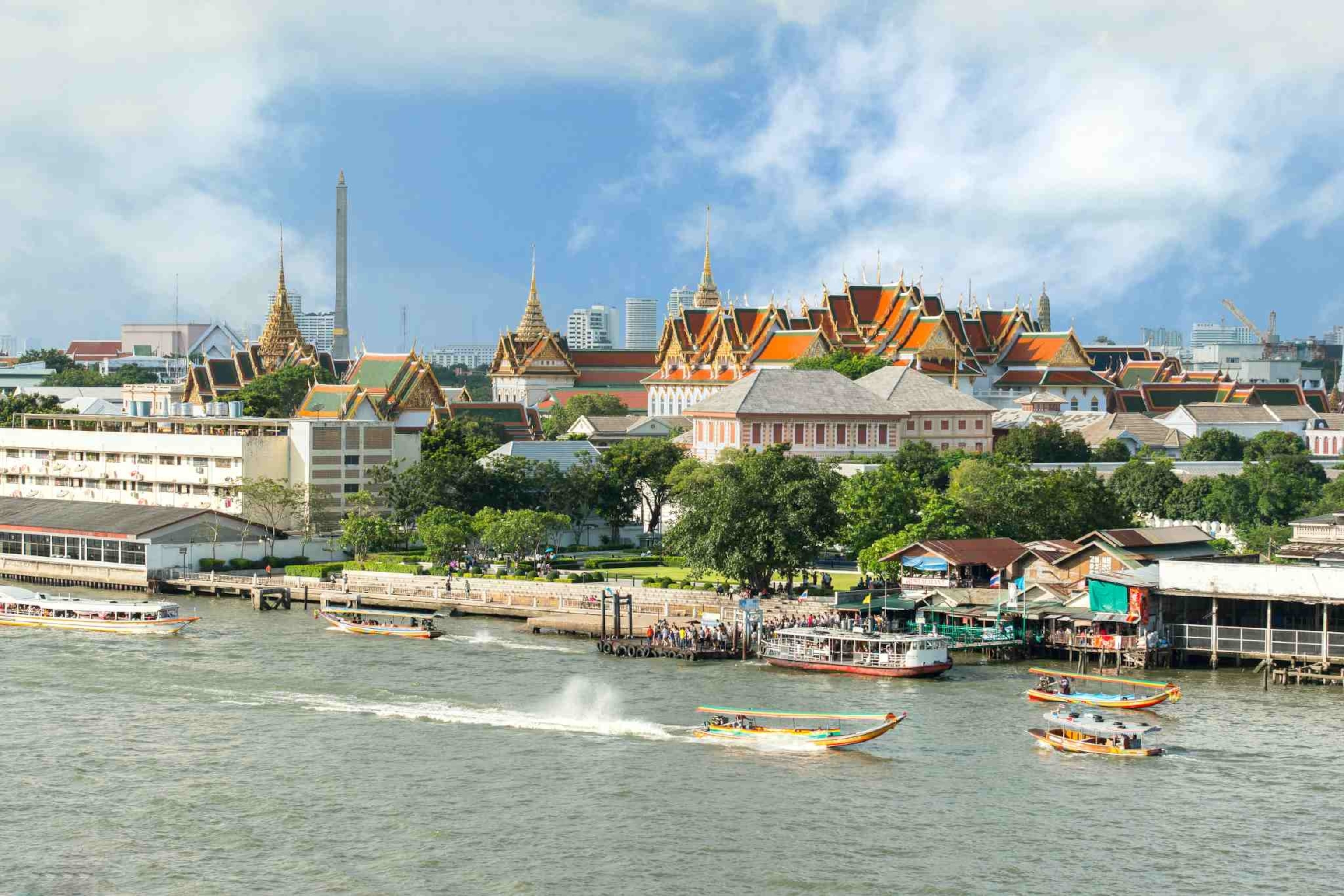
The Chao Phraya River is far more than a geographical feature; it is the historical and cultural lifeline of Bangkok. The city itself, initially established by King Rama I on the eastern bank in 1782, was deliberately shaped by the river, replicating the strategic and commercial success of the former capital, Ayutthaya.

Early Bangkok, often dubbed the “Venice of the East,” was a sprawling network of canals (khlongs) and stilted wooden houses, with the river serving as the main highway for commerce, transport, and daily life. The most iconic landmarks—the Grand Palace, Wat Arun (Temple of Dawn), and Wat Pho (Temple of the Reclining Buddha)—were strategically positioned along the banks to showcase the kingdom’s power and spiritual devotion. For centuries, the river was the primary source of connection to the outside world, fostering international trade and leading to the establishment of diverse foreign communities, such as the historic Portuguese enclave of Kudijeen, which still retains its unique architectural and culinary heritage.
Shifting Focus and Subsequent Neglect
As modern infrastructure developed in the 20th century, the focus of Bangkok’s urban planning shifted dramatically. The construction of a vast network of roads, expressways, and mass transit systems in the mid-to-late 1900s directed development inland.
The once-essential khlongs were often filled in and paved over to create roads, and the river’s immediate surroundings became associated with older, less-developed areas. Pollution and congestion on the water further accelerated the trend of residents and businesses moving away from the riverside. For a period, the river became viewed primarily as a working transport artery and a drainage system rather than a valuable public space. While luxury hotels continued to occupy prime waterfront real estate, many of the historic neighborhoods and piers fell into disrepair, losing their former prominence in the city’s life.
Revitalization and Architectural Renaissance
A major part of the current “rediscovery” is a concerted effort to revitalize the riverfront through strategic urban projects and development. This movement seeks to reclaim the river as a major public and cultural destination.
Key projects include the renovation of historic warehouses into trendy mixed-use complexes like Asiatique and the ongoing development of modern luxury residences and art spaces. A notable example of infrastructure renewal is the Phra Pok Klao Bridge Sky Park (also known as the Chao Phraya Skypark), a renovation of a defunct railway structure into the first pedestrian and bicycle bridge across the river, connecting historic communities on both the Thonburi and Rattanakosin sides. Furthermore, government and private initiatives aim to improve water quality, create new waterfront promenades, and integrate the river with the city’s modern transportation network, making river travel more convenient and aesthetically appealing. These developments are attracting a younger generation of locals and tourists to experience the “magic” of the river once more.
The River as a Modern Transport Hub
Crucially, the Chao Phraya is being rediscovered as an efficient and vital transportation corridor in a city notorious for its traffic congestion. The river offers a quick, reliable, and scenic way to navigate Bangkok, connecting major transit points.

Various water transport options, including the Chao Phraya Express Boat, long-tail ferries, and new electric Smart Ferries, cater to both commuters and tourists. The river network directly links to the city’s BTS Skytrain system at key piers like Saphan Taksin, creating an effective intermodal system. This convenience has spurred growth in riverside dining, nightlife, and cultural tourism, with dinner cruises offering dazzling views of illuminated temples and landmarks. The increasing reliance on the river for transport underscores its enduring practical value, ensuring its central role in Bangkok’s day-to-day operations and cementing its status as the city’s functional, as well as cultural, heart.

