
For almost a century, a staggering feat of ancient engineering has puzzled scientists and fuelled sensational speculation in Peru’s Pisco Valley. Known colloquially as the Band of Holes, or locally as Monte Sierpe—Serpent Mountain—this vast array of between five and six thousand pits, carved with precise alignment across a desert hillside, seemed to defy rational explanation. Since its modern discovery via aerial photography, published by National Geographic in 1933, theories ranging from pre-Inca graves to runways for extraterrestrials have compounded its enigma. Now, thanks to the confluence of twenty-first-century technology and meticulous microbotanical analysis, an international team of archaeologists has grounded the monument in human reality. The evidence suggests the holes were a dynamic form of Indigenous social technology, functioning first as a bustling pre-Inca barter market and later repurposed by the Inca Empire as a monumental, landscape-sized accounting system for tribute collection.
The Monumental Enigma on Serpent Mountain
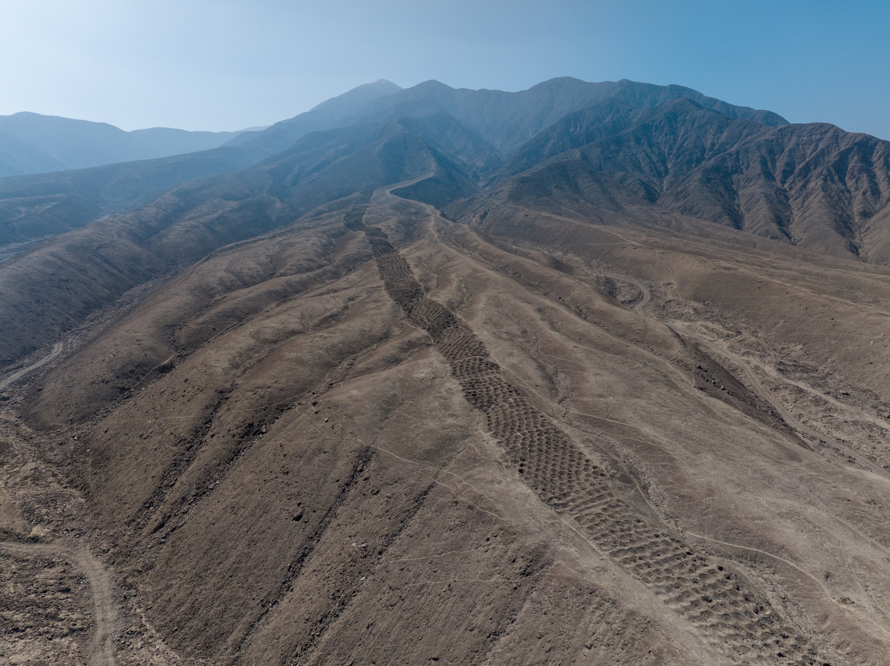
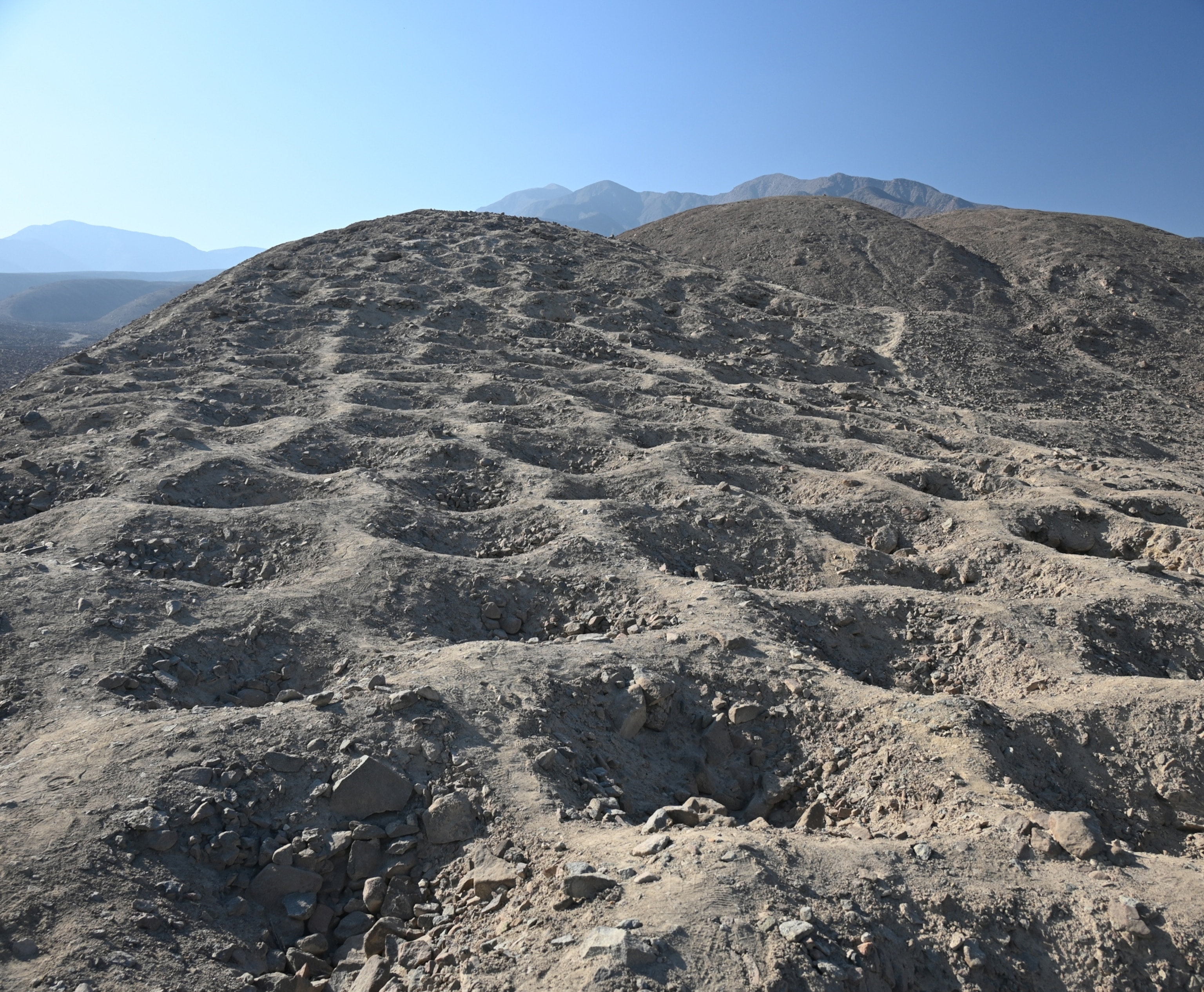
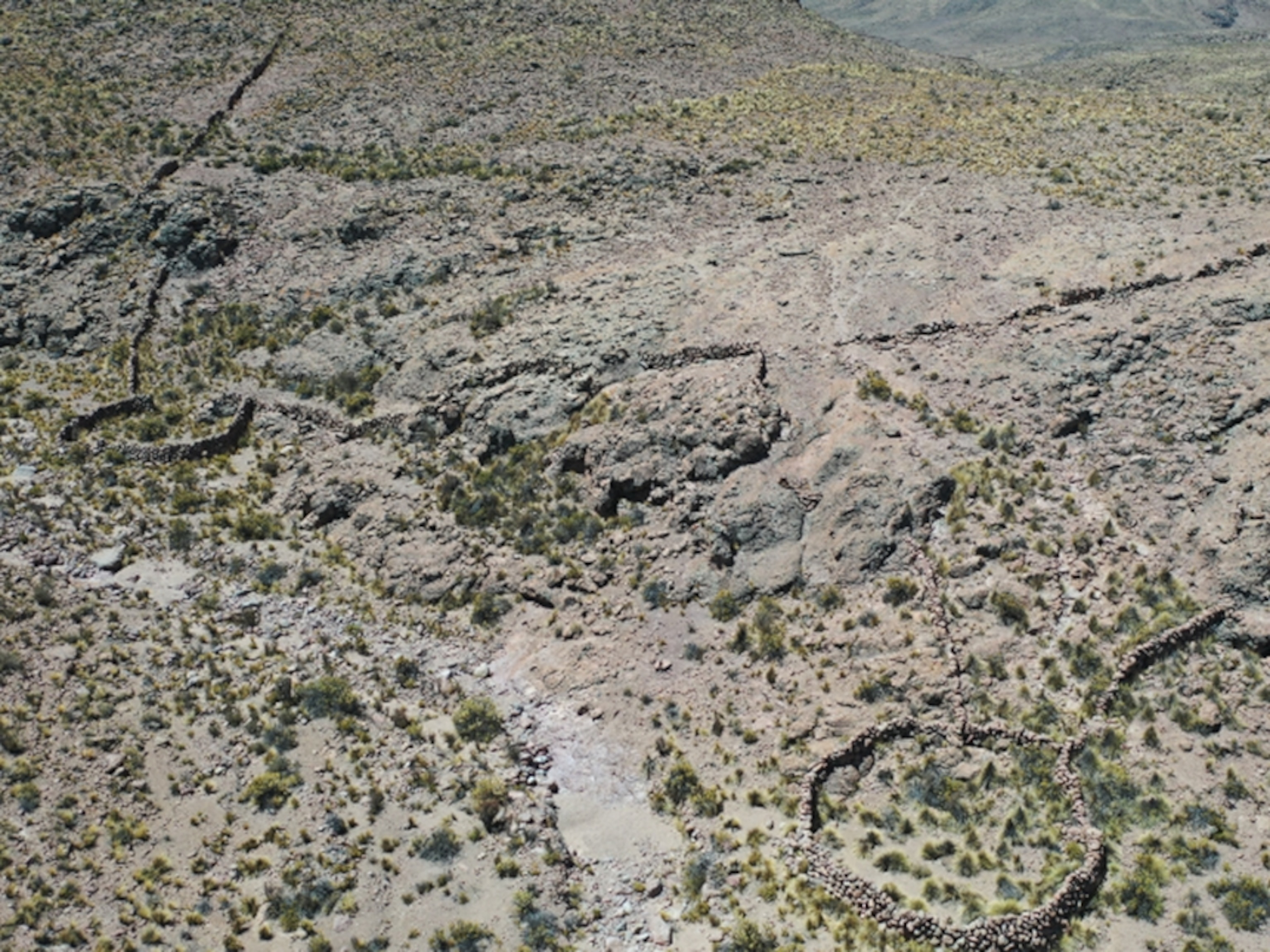
The Band of Holes is a monumental and singular landscape feature stretching for nearly a mile across a ridge above the Pisco Valley. It is an extraordinary example of organized labor, composed of thousands of precisely uniform pits, each roughly one to two meters wide and up to a meter deep, dug methodically into the uneven terrain. The sheer scale and deliberate alignment of the structure immediately suggested a crucial, if unknowable, purpose to its original builders.
When these mysterious formations first appeared in aerial photographs in the 1930s, they instantly captured the imagination of the public and confounded early archaeologists. In the absence of clear, hard evidence, the initial theories spanned a wide spectrum of possibilities. Some suggested a military function, proposing the pits were defensive foxholes or positions for soldiers surveying the coastline. Others speculated they were a system of graves, though the lack of burials in most holes quickly challenged that idea. Even more practical hypotheses, such as elaborate water collection systems or agricultural terraces, failed to explain the illogical location and monumental effort required to carve thousands of pits into an arid, rocky ridge.
The mystery was only deepened by the name Monte Sierpe, or Serpent Mountain, which either refers to the serpentine, mile-long shape of the formation as it snakes up the hillside, or perhaps nods to a lost, mythic significance. This ambiguity, coupled with the site’s stark, remote visibility, made it fertile ground for decades of pseudo-archaeological claims, linking the Pisco Valley pits to extraterrestrial visitation or the myth of a lost civilization. The true human narrative of this vast construction remained locked away for nearly a century, awaiting a new approach to unlock its secrets.
The Failure of the Naked Eye and the Rise of the Drone
For decades, the Band of Holes resisted proper archaeological interpretation because it was simply impossible to fully grasp its structure from the ground. Located in the coastal foothills, the site is often obscured by persistent haze, and the immense length of the line makes it difficult to perceive the overall pattern from any single vantage point on the ridge. This meant that while archaeologists could record the dimensions of individual holes, they couldn’t see the macro-level design that held the key to its function.
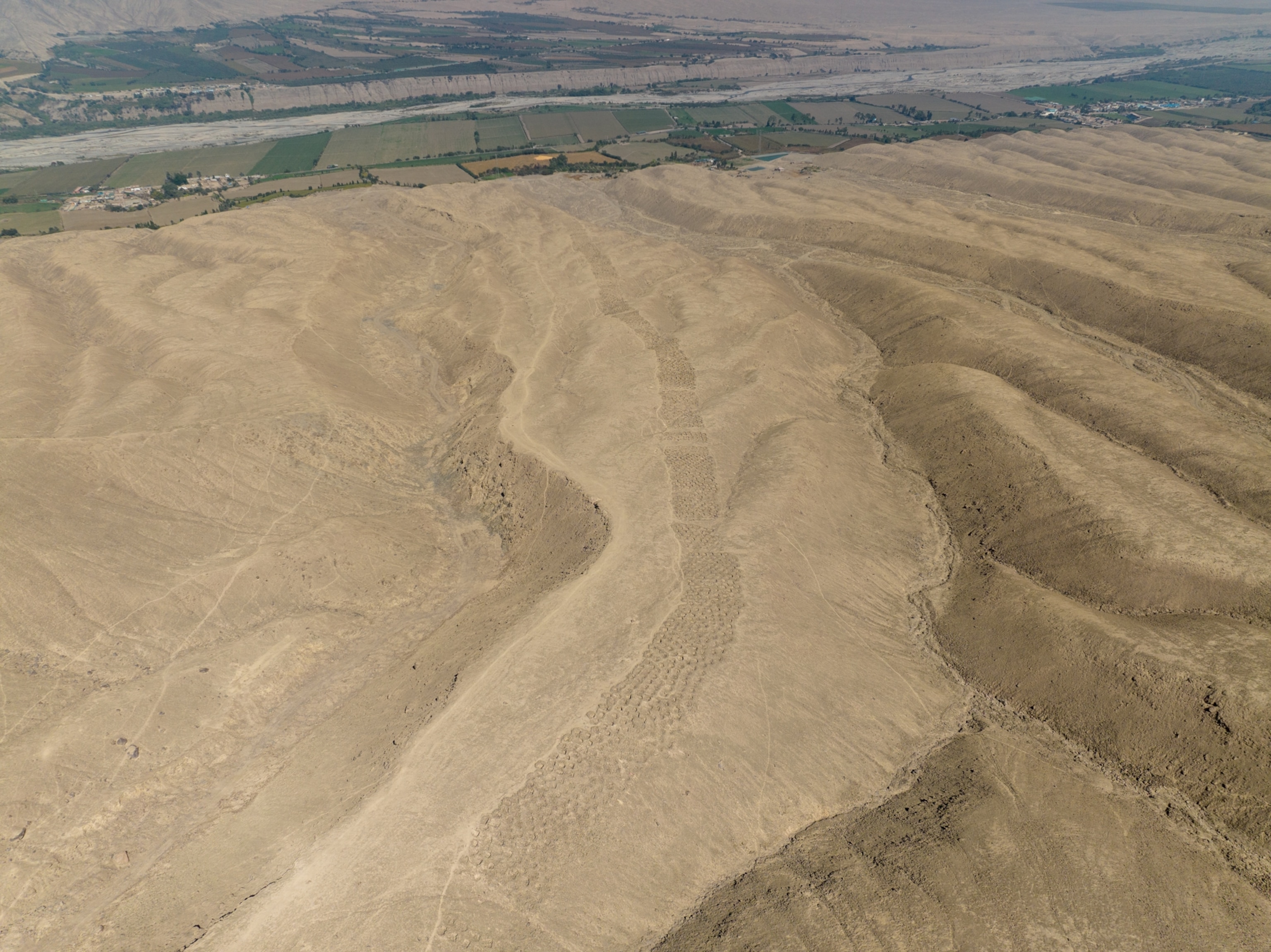
The paradigm shifted entirely with the introduction of high-resolution drone photography. New aerial surveys revealed a spectacular, previously undetectable pattern: the thousands of holes were not continuous but were organized into distinct segments or blocks, separated by small strips of untouched land. This block-like organization immediately suggested a numerical or structural logic, shattering the theory that the holes were random or merely decorative. The drone images provided the first unequivocal evidence of a structured, man-made system of counting or categorization.
This technological leap was partnered with intensive fieldwork and an international collaboration of researchers. By creating precise, detailed maps of the formation, the team could apply mathematical analysis to the layout, finally moving the debate from wild speculation to a verifiable, indigenous explanation grounded in the cultural practices of the ancient Andes. The digital mapping demonstrated that the structure was not uniform, but deliberately varied in the number of rows and holes per block, hinting at a sophisticated system of categorization and record-keeping.
Micro-Clues: Unearthing an Ancient Marketplace
The second critical component of the new study involved a meticulous microbotanical analysis of sediment samples taken from deep within the holes. While the wind carries some pollen, the discovery of specific, heavy plant materials provided indisputable evidence of human activity. The soil samples revealed starch and pollen grains from staple crops such as maize (corn) and sweet potato, along with the fibrous remnants of bulrush and other reeds traditionally used by Andean peoples for weaving baskets and bundles.
These micro-clues support the hypothesis that the site was constructed by the local Chincha Kingdom—a powerful coastal polity that predated the Inca expansion—and initially functioned as a vast, organized barter marketplace. The holes, often lined with plant matter, would have served as standardized, temporary containers or display units where traders, farmers, and fisherfolk could deposit and display their goods. Monte Sierpe sits at a crucial ecological crossroads, a meeting point where communities from the fertile coast could trade seafood and cotton with groups from the Andes highlands carrying corn, potatoes, and metal goods.
The researchers propose that the sheer act of depositing goods in the holes was a form of public information display. A certain number of holes filled with maize could have been equivalent to a certain quantity of cotton or coca, allowing for clear, standardized exchanges without the need for currency. This interpretation transforms the enigmatic holes from a desolate ruin into a vibrant, bustling ancient economic center, a monumental piece of “social technology” built to facilitate trade and human interaction in a diverse region.
A Landscape Khipu: The Inca’s Accounting Legacy
While the Chincha likely built the site as a market, the evidence strongly suggests the Inca Empire later appropriated and repurposed it during their expansion into the Pisco Valley around the 15th century. This new function was likely administrative, transitioning the site into a large-scale accounting system for state-run tribute collection. This theory is supported by the site’s geography, as it is strategically located between two major Inca administrative centers.
The strongest support for the accounting theory comes from the numerical and segmented layout of the holes themselves. The drone mapping showed that the block formations bear a striking resemblance to the structure of the khipu—the complex, knotted-string devices used by the Inca and earlier Andean groups for sophisticated census and financial record-keeping. The patterns of the holes—the number of rows and the groupings within them—echo the arithmetic relationships found in actual khipu recovered from the Pisco Valley.
The Inca Empire utilized a rigorous taxation system based on a hierarchical decimal structure, demanding tribute from local communities in the form of labor and goods. In this context, the blocks of holes on Monte Sierpe could have served as a tangible, fixed-in-the-landscape register. Each segment may have corresponded to a specific local community, with the number of holes correlating to their assigned tax quota or the quantity of goods paid in tribute. This repurposing demonstrates the Inca’s powerful ability to adapt and incorporate existing regional structures into their vast, centralized state administration.
Beyond the Speculation: Reclaiming Andean History
The new findings achieve a critical goal beyond merely solving an archaeological puzzle: they successfully reclaim the history of the Band of Holes from the realm of sensational speculation. By using modern scientific methods—drone technology, microbotanical analysis, and radiocarbon dating—researchers have grounded the site firmly within its Andean cultural and economic context, dispelling ungrounded theories about aliens or mythical lost civilizations.
Ultimately, Monte Sierpe stands as a powerful testament to the ingenuity and organizational complexity of pre-Hispanic Andean societies, particularly the Chincha and later the Inca. It represents a creative indigenous solution to the challenges of large-scale trade, economic exchange, and governance in a region without a written script. While the exact details of the khipu connection remain a subject of ongoing research, the mystery of the monumental construction is largely solved. The only question that lingers is why this remarkable landscape khipu, this unique fusion of marketplace and tax office, was built only here and not replicated across the vast expanse of the Inca Empire.


